"The most learned of men is the one who gathers knowledge from others on his own; the most worthy of men is the most knowing and the meanest is the most ignorant."
Hazrat Muhammad صَلَّى اللّٰهُ عَلَيْهِ وَسَلَّم
Geospatial Educator & Professional
Geospatial Activities

Visualizing Precipitation Calendar using R (June, 2022)
When and How Much Did it Precipitate in Murree (2021)
Made in R

Animated Nighttime Light Map of Pakistan (June, 2022)
Animated Nighttime Light (#NTL) Map of #Pakistan (1992-2020) made in #R using a harmonized global nighttime light dataset produced by Li et al. (2020).
#Datavisualization #dataviz #geoviz #animation #adeelgeographer

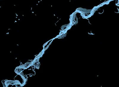
Visualizing Hydrological Streams using R (May, 2022)
DataVisualization using R. Rivers of Pakistan visualized using HydroSHEDS Database developed by WWF
#datavisualization #R #river

Landcover Change Animation of Lahore District, Pakistan (May, 2022)
27 years of Landcover Change in Lahore District, Pakistan (1990-2017). Reconstructed time-series made using our recently published book chapter entitled "Spatiotemporal urban sprawl and land resource assessment using Google Earth Engine platform in Lahore district, Pakistan".
#datavisualization #landcover #change #gee #lahore #pakistan #urbanstudies

3D Population Map (May, 2022)
My first attempt to make a 3D map in R. The map is showing population density of Punjab Province, Pakistan for 2020.
#r #rstats #datavisualization #dataviz #punjab #population #pakistan #3dmapping

WordCloud in R, Pakistan (June, 2021)
Playing around with R
A WordCloud of Words used in the titles (a few authors as well) of published papers on Pakistan's forests using Remote Sensing
#R #Pakistan #remotesensing #gis #forests

Wind trajectory animation over Azad Jammu & Kashmir (AJK) and Punjab, Pakistan (April, 2020)
Just created this wind trajectory animation above Azad Jammu & Kashmir and Punjab in Pakistan. This wind trajectory (dated 20th April, 2020) is made using ECMWF's (European Centre for Medium-Range Weather Forecasts) ERA-5 (ECMWF Reanalysis 5th) hourly wind data. A low-pressure gradient is clearly visible at the north-eastern part of Punjab province.
#gee #googleearth #googleearthengine #mapping #AJK #Punjab #geography #adeelgis #adeelgeographer #wind #trajectory #lowpressure #pressuregradient #spatiotemporal #remotesensing #GIS #animation

Urbanization and river Ravi's meandering over decades, Lahore - Pakistan (1984-2020)
Interesting animation showing river Ravi's meandering and Urbanization of Lahore from 1984 to 2020
#gee #googleearth #googleearthengine #mappin #Lahore #geography #adeelgis #adeelgeographer #riverravi #ravi #rivermeandering #meandering #spatiotemporal #remotesensing #GIS #animation

Transboundary dust plumes animation over Pakistan and India (2020)
Made this animation in GEE to show the dust plumes transboundary movement over Pakistan and India in early months of 2020
#gee #googleearth #googleearthengine #mappin #Lahore #geography #adeelgis #adeelgeographer #animation #dustplumes #sentinel

Uneven population distribution in selected districts of Pakistan
Here's a comparison of cumulative population (1998 & 2017) of selected districts of Pakistan. It is interesting to note that cumulative population of 2 districts (Lahore & Karachi) alone is almost equivalent to 38 districts of Pakistan (including cumulative population of area-wise largest province of Pakistan i.e. Balochistan province, 4 districts of Sindh province and 2 districts of Punjab province).
It is also interesting to note that the cumulative area of these two districts (Lahore & Karachi) is only 1.25% of cumulative area of these selected 38 districts.
#mapping #pakistan #population #populationgeography #geography #adeelgis #adeelgeographer #gis #spatial #geospatial #cartography

Independence abstract map
Happy Independence Day, Pakistan| 2020
I am sharing this abstract map again that I actually made on 14th August, 2011. The map is made out of Lahore's road network and few selected polygons.

Elevation with hexagonal tessellation
Elevation mapping using Hexagonal Tessellation approach (Azad Jammu & Kashmir)

LandTrendr Google Earth Engine (GEE)
Tried a LandTrendr GEE using a tutorial. The animation is showing spatiotemporal change in Islamabad (1984-2019).
#gee #googleearth #googleearthengine #landtrendr #mapping #islamabad #geography #adeelgis #adeelgeographer #spatiotemporal #animation #bigdata #geospatial

Annual NDVI animation over Pakistan
Just made this interesting animation showing annual vegetative cover variation (January, 2019 - January, 2020) in Pakistan. This animation has been made in Google Earth Engine (GEE). MODIS dataset's 16-Day Normalized Difference Vegetation Index (NDVI) at 1km resolution has been used to generate this animation.
#gee #googleearth #googleearthengine #ndvi #mapping #pakistan #geography #adeelgis #adeelgeographer #NormalizedDifferenceVegetationIndex #worldenvironmentday #Lahore #environmentday #5thjune #spatiotemporal #remotesensing #GIS #animation #bigdata #bigspatialdata #geospatial #geospatialdata
Visualizing river meandering through GEE
A quick output of Lahore’s River Ravi animation demonstrating a cumulative and fading history technique in Google Earth Engine. The dataset used contains classified satellite images of the spatio-temporal distribution and change of surface water from 1984 to 2018. (Data Source: Global Surface Water Explorer | European Commission)
#gee #googleearth #googleearthengine #nightlightmap #mapping #pakistan #geography #adeelgis #adeelgeographer #riverravi #ravi #Lahore #rivermeandering #meandering #spatiotemporal #remotesensing #GIS #animation

Night light map of Pakistan
Night Light Map of Pakistan | After a long gap, was just exploring Google Earth Engine (GEE)
#gee #googleearth #googleearthengine #nightlightmap #mapping #pakistan #geography #adeelgis #adeelgeographer

Cultural abstract map of Pakistan
An abstract map of Pakistan based on cultural dresses in each of its administrative division
#mapping #pakistan #geography #adeelgis #adeelgeographer #culture #cultural geography

Seismic zonation map of Pakistan
This map we produced for an assignment during our MPhil in Geomatics. Our research group was named as "MAAU".
#mapping #pakistan #geography #adeelgis #adeelgeographer #earthqquakes #seismic #zones #MAAU

Forests and sanctuaries of Pakistan
A database of all forests and sanctuaries of Pakistan.
#mapping #pakistan #geography #adeelgis #adeelgeographer #forests #santctuaries #biomass

Air pollution in Lahore, Pakistan
A map of air pollution in various important junctions of major city of Pakistan labeled in Urdu language.
#mapping #Lahore #geography #adeelgis #adeelgeographer #airpollution

Multi-indicator map of Pakistan
This multi-indicator map of Pakistan was produced by our research group when I was in FCCU. The students collected the data and I designed the map.
#mapping #Pakistan #geography #adeelgis #adeelgeographer #poverty #labourforce #schoolratio #cropproduction

Customized travel map
A friend of mine asked me to make a map of his upcoming official trip so this is what I made.
#mapping #Pakistan #geography #adeelgis #adeelgeographer #travelmap

